Wall Builders in Saint-Alban-Auriolles
SAINT-ALBAN-AURIOLLES
Wall Builders in Saint-Alban-Auriolles
Medium
3h15
9,3km
+176m
-176m
Loop
PR
A circuit without great difficulty. The paths are however very stony in places and the limestone slabs can be very slippery.
Embed this item to access it offline
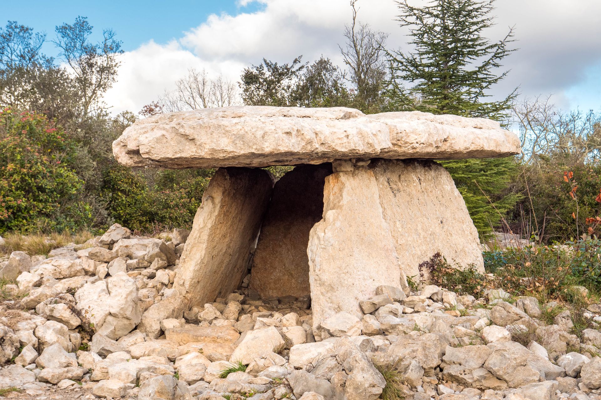
Hiking on trails, paths and small roads that cross the grasses (scrubland with clay-limestone soil). Low walls, piles and shelters (capitelle) built from dry stones, dolmen, chapel, In places, the path winds between limestone rocks. On both sides, downy oaks share the terrain with rocky chaos.
Description
Exiting the parking lot behind the community hall, turn left. At the first intersection, continue slightly to the right.
- At the hiking signpost labeled "Cimetière," go left toward "Le Calvaire 0.7 km" or "Le Dolmen 1.1 km." About 200 meters further, take a path on the right along a small stream that leads to a cave overlooked by houses. Exit between the houses and then turn right to follow Rue Montée de la Barnerie. At a curve to the right (toward number 245), take a wide concrete path on the left alongside a house for about ten meters. It climbs steeply and narrows. A few meters further, turn left and climb a path shared with the Stations of the Cross that leads to St. Peter's Chapel and beyond.
- At the "Le Calvaire" signpost, follow "Le Dolmen 0.3 km - Les Falaises de Lunel 3.8 km" to the left. Take a path lined with dry stone walls. After 100 m, you can visit the dolmen and back. In wet weather, be very careful of the slippery slabs that cover almost the entire ground surface. Then continue on the path.
- At the "Le Dolmen" signpost, follow "Les Falaises de Lunel 3.8 km - Joyeuse 9.3 km" to the right. Continue on a narrow path lined with low walls. Along the way, you will discover a capitelle: a dry stone structure that served as a shelter for shepherds. At the intersection, turn right. The path widens, and at the next intersection, turn left onto the path.
- At the "Ventalon" signpost, follow "Les Falaises de Lunel 1.4 km - Joyeuse 7.2 km" to the right. At the next intersection, turn left. The path gradually winds between rocks and oak trees. In a narrow passage, turn right and join a wider path.
- At the "Falaise de Lunel" signpost, follow "Labeaume 4.5 km - St Alban-Auriolles 4.6 km" to the right. Take a wide, stony path offering magnificent views of the Beaume River, the locality of Gadret located on the water's edge, the hamlet of Linsolas, and the Chapias Tower on the plateau. At a paved road, turn left.
- At the "Robert" signpost, follow "St Alban-Auriolles 2.2 km" to the right. Walk alongside a vineyard, then descend through the woods.
- At the "Le Bourdaric" signpost, follow "St Alban-Auriolles 0.8 km" to the left. Continue along a path lined with low walls. At the intersection with a paved road, turn right to reach the "Cimetière" sign. From there, follow "Info Rando 0.3km"; and take the same route as on the outward journey but in reverse.
- Departure : 81 Rue Marius Perbost, 07120 Saint-Alban-Auriolles GPS : 44°25'37.66"N / 4°18'3.54"E
- Arrival : 81 Rue Marius Perbost, 07120 Saint-Alban-Auriolles GPS : 44°25'37.66"N / 4°18'3.54"E
- Towns crossed : SAINT-ALBAN-AURIOLLES and JOYEUSE
Forecast
Altimetric profile
Recommandations
The white and yellow markings are missing in many places on this hike, so follow the GPS track and the description carefully.
Good shoes and possibly walking sticks. Water bottle and hat.
Information desks

Office de Tourisme Gorges de l'Ardèche - Ruoms
9 rue Alphonse Daudet, 07120 Ruoms

Office de Tourisme Gorges de l'Ardèche - Vallon-Pont-d'Arc
16 rue des Abeilles, 07150 Vallon Pont d’Arc
Access and parking
From Vallon or Vogüé: take the D579 to Ruoms, then the D4 towards Labeaume, then the D208 to Saint-Alban. The car park is located behind the town hall at 320 Av. Pasteur.
Parking :
Parking behind the town hall 81 rue Marius Perbost 07120 Saint-Alban-Auriolles
Report a problem or an error
If you have found an error on this page or if you have noticed any problems during your hike, please report them to us here: