The viewpoints and statues of Viviers
This hike isn't very long, but the trails leading up and down from the viewpoints at the base of the statues are steep and rocky. They can even be a little slippery.
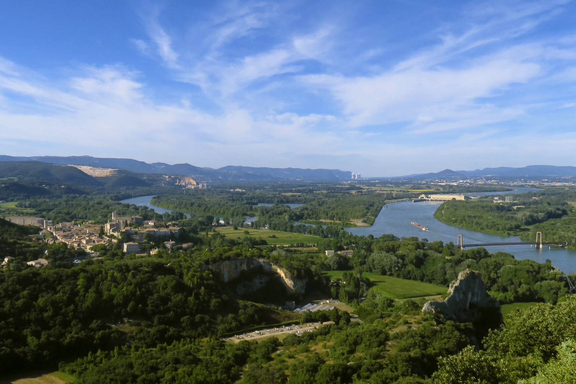
Start with the rich architectural heritage of Viviers. Seen from above then from within. Then a small road takes you to the foot of Saint-Michel hill and a path through the undergrowth takes you up to its statue offering superb views. Ridge path then descent through the undergrowth before following wide, flat paths in the gorge.
Description
- From the Tourist Office, cross the road. Go uphill, taking Rue des Auches to the left. Follow the signs. Climb the path that starts to the right of the cemetery entrance and then passes over it. When you reach the water tower, turn left. Follow the path to the left to reach the statue of the Virgin. You have a panoramic view of the town, Saint-Vincent Cathedral, and the 18th-century Episcopal Palace, the current site of the town hall.
- Pass to the right of the statue. Take a small, winding path, quite steep at first, to descend back towards the town. At the road, turn left, then cross beyond the roundabout to reach Place Prosper Allignol, where the Hôtel du Roc (now the Bishop's Palace) is located. Take Grande-Rue on the left. This was once the town's main artery. You'll pass several 18th-century mansions.
- At the end of the main street, cross Place de la République and admire the Maison des Chevaliers on the left. Its highly decorated Renaissance façade was commissioned by a local merchant: Noël Albert. Retrace your steps and go left, then right, up Rue du Château. Signposted. After 150, turn left, passing under the gate to go up to the cathedral. Go to the Esplanade de Châteauvieux on its left. Then return to the square and cross Place Saint-Jean. Take the vaulted passageway and then go down the stairs on the left.
- Cross the road at the passage on the left and go down towards the Rhône. Walk along the wall and take the first small road on the right. Follow the signposts again. The old port was located at the cliff on the right. You can see the holes in the cliff for the rings used to moor boats. This is where Richelieu landed in 1642. Continue on the paved road. Do not take the path that leads up to the cemetery. After walking along a stone wall on your left, a sign indicates that you must turn right.
- Take the path that leaves the road and, after passing under some trees, climb to the right, pass at the foot of the cliff, and take the path that leads up into the woods.
- Caution for children: dangerous passage near a cliff. Arrive at the statue of Saint Michael slaying the dragon. It measures 9.5 meters. It was erected by the town of Viviers after the Second World War to thank Saint Michael for protecting it from bombing. Retrace your steps to the post with the yellow sign, then turn left. Be careful, there is a steep descent for a few meters between large rocks. The path descends into the undergrowth, then climbs back up to follow the ridge; then plunges to the right again into the undergrowth. Towards the end of the descent, a path on the left allows for a short round trip to admire a natural arch (probably carved into the rock by the waters of the Rhône). Be careful not to venture too close: risk of falling. When you reach the houses, turn left onto the road. Quickly leave it to take the first path on your left. This leads to a track. Take the wooded path that descends to the left (follow the yellow and white markings carefully). Then turn left onto the wide path that runs along the foot of the hill, heading north. At the end of the path, take the path on the right.
- When you reach the paved road, turn left. After 50 meters, take the ViaRhôna on your right and continue towards the port; from there, take the Allée du Rhône to Place de la Roubine. Turn right there, then left onto Rue Chèvrerie. At the end of this road, go uphill to the right to return to the Tourist Office.
- Departure : Viviers Tourist Office
- Arrival : Viviers Tourist Office
- Towns crossed : VIVIERS
Forecast
Altimetric profile
Recommandations
Walking sticks.
Good shoes
Information desks

Office de Tourisme Gorges de l'Ardèche - Bourg-Saint-Andéol
Place du Champ de Mars, 07700 Bourg-Saint-Andéol
Office de Tourisme Gorges de l'Ardèche - Viviers
5 place Riquet, 07220 Viviers
Transport
Stop: La Poste
BUS E19: Montélimar - Le Teil - Viviers - St-Thomé
Keolis line E19 • 04 75 44 10 33
BUS E20: Montélimar - Le Teil - Viviers - Bourg-St-Andéol - Pont-St-Esprit
Keolis line E20 • 04 75 44 10 33
Access and parking
From Aubenas, follow the N102 towards Alba-la-Romaine, then the D107, then the D86 to reach Viviers. Park near the Tourist Office.
From Montélimar, follow the D73 to Châteauneuf-du-Rhône and beyond to Viviers. At the roundabout after the bridge over the Rhône, turn right and park near the Tourist Office.
From Vallon Pont d'Arc, take the D4 to Bourg-Saint-Andéol, then head north on the D86 to reach Viviers.
Parking :
Report a problem or an error
If you have found an error on this page or if you have noticed any problems during your hike, please report them to us here: