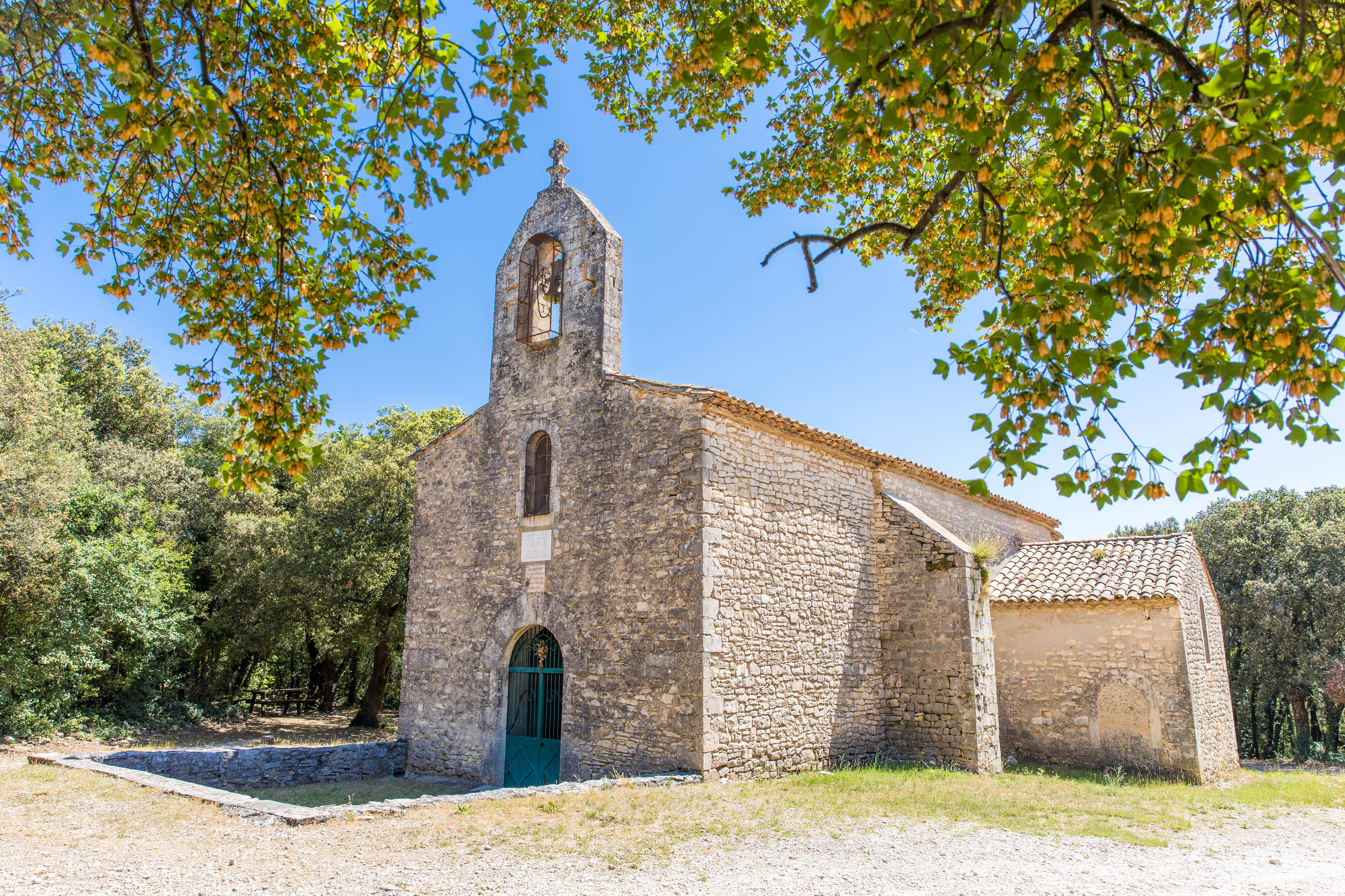
The Chalon Chapel in the Laoul Forest by mountain bike
Forest tracks that may be quite steep, rocky or rutted in places.
Paths through a forest of oak, acacia, deciduous and pine trees. A 12th-century Romanesque chapel situated in a beautiful clearing.
Description
From the hiking information board at the Forest House, join the D4 and follow it to the left for 100 metres; then turn onto the first forest track on the right. Follow the markings.
- At the “La Forestière” signpost, follow “Combe des Acacias” and take the forest track for around 150 metres
-
At the signpost marked “Combe des Acacias”, follow the sign for “Plaine de Mias” 2.8 km to the left. Walk down the Combe des Acacias for around 2 km, then head up a fairly steep, stony path on the right. Pass by the remains of charcoal burners’ and shepherds’ huts. Descend to the junction marked “Plaine de Mias”. From there, head up to the right towards “Combe du Renard” (0.8 km) along a path through the woods. You will pass by more old charcoal burners’ huts before joining the GR42 on a wide track.
- At the signpost for “Combe du Renard”, turn left towards “Bois du Sorbier”, 0.1 km away.
- At the “Bois du Sorbier” signpost, turn right towards “Moure de Trian”, 1 km away. Follow this path through a pine forest. At the T-junction, head down the Chalon valley to the left
- At the signpost marked “Moure de Trian“. When the path joins a track, follow it to the right until you reach a clearing where the signpost will be approximately 20 metres to the right of the track.
- At the signpost marked “Chêne rond”, follow the sign for “Terre Longue” for 1 km and take the wide path that climbs gently northwards.
- After 200 metres, you will come to the beautiful Chalon Chapel. It is a peaceful spot, perfect for a picnic break in the sun or shade. Then take the tarmac road to the “Terre longue” signpost and turn right there towards “Chalon”, 0.2 km away. As you come out of the woodland path, cross the road.
- At the signpost marked “Chalon”, turn left towards “Combe des Acacias” (1 km) and when you come out onto a wide track, continue in the same direction. At the “Combe des Acacias” signpost, turn left towards “la Forestière” (0.1 km). At the “la Forestière” signpost, cross the road, turn left and take the path on the right which leads back to the Maison Forestière.
- Departure : Laoul Forest Centre
- Arrival : Laoul Forest Centre
- Towns crossed : BOURG-SAINT-ANDEOL
Forecast
Altimetric profile
Recommandations
Take care around areas where driven hunts are taking place during the hunting season. The first descent can be very rugged: proceed with caution.
Information desks

Office de Tourisme Gorges de l'Ardèche - Bourg-Saint-Andéol
Place du Champ de Mars, 07700 Bourg-Saint-Andéol
Office de Tourisme Gorges de l'Ardèche - Larnas
Le Village, 07220 Larnas
Access and parking
From Bourg-Saint-Andéol, follow signs for Saint-Remèze and Vallon-Pont-d'Arc via the D4. Just after the right-hand bend, 500 metres past the top of the hill, turn right onto a wide forest track. The car park is on the left.
From Vallon-Pont-d'Arc, head towards Saint-Remèze and Bourg-Saint-Andéol via the D4. At the end of the long straight stretch through the forest, just before the left-hand bend, turn left onto a wide forest track. The car park is on the left
Parking :
Report a problem or an error
If you have found an error on this page or if you have noticed any problems during your hike, please report them to us here: