Through the combe and vineyards of St-Marcel-d'Ardèche
SAINT-MARCEL-D'ARDECHE
Through the combe and vineyards of St-Marcel-d'Ardèche
Easy
3h30
11,6km
+187m
-186m
Loop
GR
PR
Embed this item to access it offline
This warm medieval village with its ochre colours and narrow streets paved with pebbles from the Rhone is distinctly charming. This small walled village is famous for its cave (Saint-Marcel), its vineyards in the heart of the Côtes du Rhône and its emblematic buildings such as the Château de Bernis, the chapel Saint-Joseph and the chapel Saint-Julien.
Description
- From the hiking information board on Place du Ponteil, near the old post office in Saint-Marcel, cross the square with the wash house and take the alley on the right, Rue de la Fontaine de Viviers. Then turn right onto the square and take the first street on the left. Next, walk past the church on the right along Rue Prunier. At the end of the street, turn left onto Rue du Barry, then take the first right and the first left. Continue for 80 m and
- take the street on the right that climbs steeply towards the St-Joseph chapel. Continue on this road and, when you reach a fork,
- continue on the left. At the end of a wood on your right,
- turn left.
- At the T-junction, turn left, then take the first path on the right. Continue along the main path until you reach a small tarmac road. Follow it downhill to the right for 130 m.
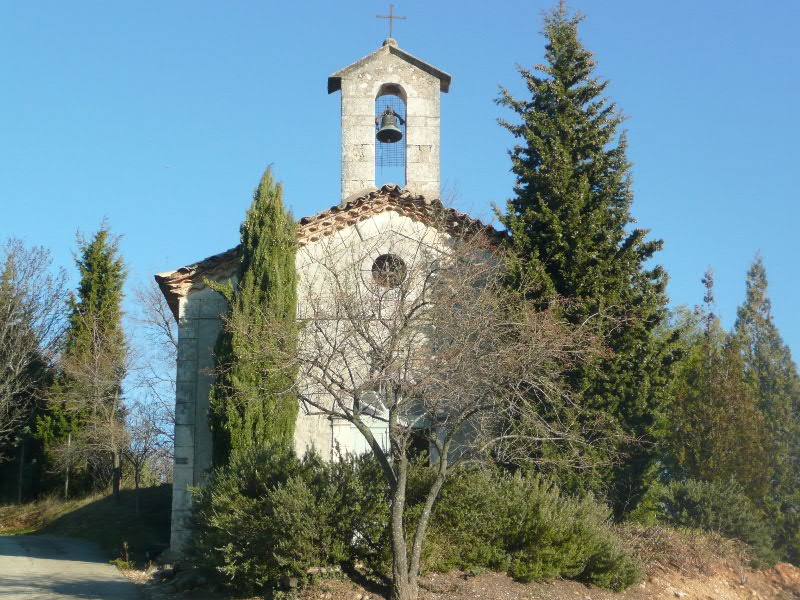
- At the ‘Souchas’ signpost, follow the signs for Chapelle St-Julien (0.3 km) straight ahead.
- At the Chapelle St-Julien signpost, leave the road and go straight up towards La Garoune Bas (0.8 km). After admiring the chapel and its bucolic setting, take the first path on the left. It winds down to the road.
- At the La Garoune Bas signpost, turn right towards La Garoune (0.2 km). Before the road turns, go up to the left towards a house and go around it on the right (markings on the electricity pole), then go down the path through the woods. Turn left onto the road. You will see the La Garoune signpost on your left. Turn left and follow the Combe du Chat stream bed for 1.65 km until you reach a wide path. Take it to the left.
- At the fork a little further on, continue to the right. When you reach the departmental road, take the path that runs alongside it to the right.
- At the second path on the other side of the road, cross and then turn right. When you reach a road, follow it to the left to Labégude.
- Turn left just after the large stone building. Follow the farm track until you reach a road and follow it downhill to the Champ de Grézas signpost. Turn left here towards Plan de Lage (0.5 km).
- After the Chapitre estate, turn right and follow this road, which then turns left. At the Plan de Lage signpost, turn left to continue on the GR42 towards Saint-Marcel-Ardèche.
- At the Lafare signpost, leave the GR 42 and rejoin the PR (white/yellow markings). Continue to follow the white/yellow markings to reach Place du Ponteil, the starting point of the hike.
- Departure : Walking information board, at the Ancienne Poste (old post office)
- Arrival : Walking information board, at the Ancienne Poste (old post office)
- Towns crossed : SAINT-MARCEL-D'ARDECHE
Forecast
Altimetric profile
Recommandations
This walk is at its best in autumn, when the vines take on their flamboyant colours.
Access and parking
From Aubenas or Montélimar, take the D86 to Saint-Marcel-d'Ardèche, following the Rhône.
From Vallon-Pont d'Arc, take either the D290, the route des Gorges, or the D4 towards Saint-Remèze, then Bidon and Saint-Marcel-d'Ardèche.
From Bollène or Bagnols-sur-Cèze, take the D86 from Pont-Saint-Esprit to Saint-Marcel-d'Ardèche.
Park in the Place du Ponteil car park, next to the Ancienne Poste.
Parking :
Car park next to the Rue du Lavoir
Report a problem or an error
If you have found an error on this page or if you have noticed any problems during your hike, please report them to us here: