Between the villages of Ruoms and Labeaume
The hike from Ruoms to Labeaume is a 9 km route that alternates between ancient villages and natural landscapes.
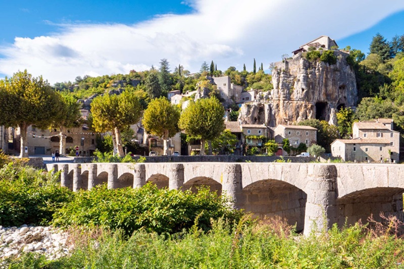
You pass over the Ardèche and skirt the heights of the river La Beaume, discovering the charming village of Labeaume. The trail offers a pleasant transition between shady and sunny stretches, with several swimming spots along the way.
We invite you to wander through the calades of Labeaume or venture into the old town of Ruoms.
Attachment
- Downloadpdf
FR - Rando n°26B - Entre Ruoms et Labeaume
Credit: Office du Tourisme Gorges de l'Ardèche Pont d'Arc
Description
Opposite the Tourist Office, turn left towards the town centre onto rue Alphonse Daudet. At the end of this street, turn right into rue Nationale (the street with the shops). Continue along rue des Brasseries. Cross the bridge over the Ardèche and turn left; then take the first turning on the right, signposted "Labeaume".
- At the end of the straight, turn left, then immediately right. At the "Peyroche" signpost, turn right towards "Labeaume 2.7 km".
- At the "Champlautier" signpost, turn left towards "Labeaume 2.2 km". When the path joins a wider track, continue straight ahead. Follow the yellow and white signs. Turn left onto the D245 road. Follow this road for 300m until you reach a crossroads. Turn left onto the cul-de-sac that leads down into the village, past the statue of the quarryman. Go as far as the river.
- At the "Le Sablas" post, cross over the submersible bridge.
- 100m further on, at the "La Beaume" sign, take the path that climbs to the right. A little further on, a path on the right takes you up and back to a superb viewpoint over the village.
- At the "Champagnac" signpost, turn left. Follow the road to a "T" and turn left. At the Chavetourte equestrian centre, take the path straight ahead as it descends and narrows. When you reach a street, continue downhill to the right. When you reach "Chemin de Bizac", go a few metres to the right and then take the path that goes down to the left. Continue straight on.
- At the signpost for "Le vieux Pont", turn left onto the main road. 200 metres after the bridge, turn left. Go through the hamlet of Peyroche and stay on the small road until you reach the "Peyroche" sign. From here, follow the road in the opposite direction as far as Ruoms.
- Departure : Ruoms Tourist Office
- Arrival : Ruoms Tourist Office
- Towns crossed : RUOMS, LABEAUME, and SAINT-ALBAN-AURIOLLES
Forecast
Altimetric profile
Recommandations
If the weather is fine, take a swim at one of the beaches along the river. And for heritage lovers, visit the narrow streets of the old village of Labeaume.
WARNING! For your own safety, the safety of others and the protection of the natural environment, during periods of drought or extreme heat, to prevent fires from starting:
- do not smoke; if you do, place your cigarette ends in a pocket ashtray (an ember or a cigarette end that has not been properly extinguished can cause a fire several hours after being discarded);
- avoid anything that could act as a ‘magnifying glass’ on dry vegetation (glass, bottles, etc.);
- no campfires, barbecues, camping stoves, candles or oil lamps.
De bonnes chaussures de marche, une gourde et éventuellement de quoi se protéger du soleil.
Information desks

Office de Tourisme Gorges de l'Ardèche - Ruoms
9 rue Alphonse Daudet, 07120 Ruoms

Office de Tourisme Gorges de l'Ardèche - Vallon-Pont-d'Arc
16 rue des Abeilles, 07150 Vallon Pont d’Arc
Transport
X76 Valence TGV - Montélimar - (Ruoms) - Vallon-Pont-d'Arc line
E15 Avignon - Vallon-Pont-d'Arc - (Ruoms) - Aubenas line
Access and parking
From Aubenas, take the D579 towards Vogüé, Gorges de l'Ardèche as far as Ruoms.
From Vallon Pont d'Arc, head towards Aubenas as far as Ruoms.
From Alès, take the D104 towards Aubenas. Then take the D111 towards Gorges de l'Ardèche as far as Ruoms.
Parking :
Report a problem or an error
If you have found an error on this page or if you have noticed any problems during your hike, please report them to us here: