The Puy Lacher
BESSAS
The Puy Lacher
Hard
3h45
9,2km
+452m
-452m
Loop
The 800-metre diversions from the main path to Puy Lacher is very steep and can be very slippery in wet weather, as can the rocky slabs at the viewpoint.
Embed this item to access it offline
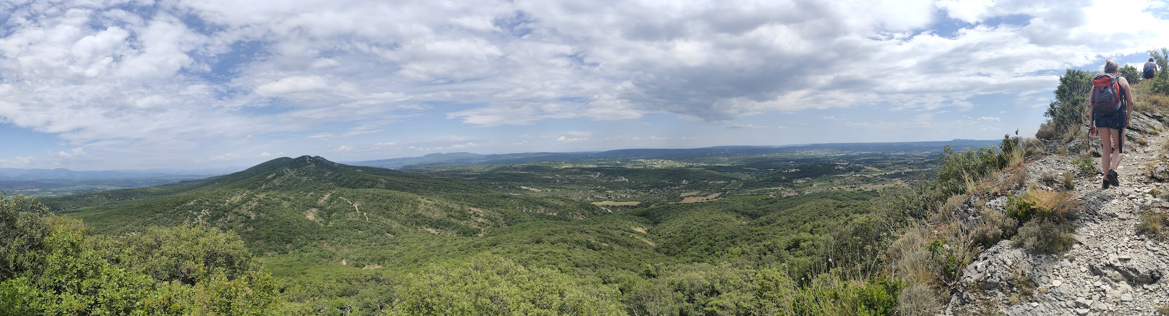
A hike through the scrubland with a good elevation gain and multiple viewpoints. The highlight of the hike is the view from Puy Lacher, which offers a 360° panorama of the Ardèche, Gard and Vaucluse departments, stretching as far as the Bouches-du-Rhône: Dent de Rez, Gorges de l'Ardèche, Dentelles de Montmirail, Alpilles, Mont Ventoux, Mont Bouquet, and more.
Description
- From the Rando information board in the car park below the town hall, you can reach the road above it via a wooden staircase. Turn left and follow the paved road for about 300 metres.
- Once you reach the cemetery, take the path to the right at the Seveyras junction to follow Col de la Cize 5.3 km Grospierres 9.1 km. The unpaved path leads to numerous fields. Stay on the path. At a junction, take the path to the left.
- At a steep climb, turn left and follow a narrower, stony path. At the entrance to the forest, the path becomes a trail. At the top, the path splits in two. Take the path on the right, which leads along the mountain to the Bartras junction.
- Turn left and follow Col de la Cize 2.2 km Grospierres 5.9 km The path climbs steadily to the fork Colombou
- Follow Col de la Serre 2.8 km Bessas 4 km. Walk along the mountain and then down again. This very narrow path offers a very nice panorama. Meet a very stony path going downhill. At the next crossroads on a small plain, leave the path going downhill to the left.
- Follow the signs on the wooden sign "Le Puy Lacher / Crête des Cruzières". Follow the small path on the left leading uphill. You are now in the undergrowth with a considerable difference in altitude.
- Turn right and follow a small path on the opposite side that climbs up through the forest until you reach the Serpentière fork, follow "Sommet du Puy Lacher - 0.4 km". You will then occasionally walk along the rock face and there are a few passages with rocks to cross. Be particularly vigilant here. From this summit, you have views of the plain of Beaulieu and the mountains of the Ardèche and Lozère to the north and south, views of the plain of Barjac, the start of the Gorges de l'Ardèche, the Dent de Rez, Mont Bouquet to the south, Mont Ventoux, the Dentelles de Montmirail, the Alpilles, the Vercors plateau and the Massif de la Vanoise. Reach the previous fork; watch out for the very steep (and slippery in wet weather) descent. At the Serpentière sign, turn right Col de la Serre 1 km Bessas 2.2 km. Follow the path and admire two old charcoal ovens along the way.
- Arrive at the Sous le Puy Lacher junction. Follow Bessas for 2 km. At the end of the forest, climb up a small embankment and then walk across between vineyards and past olive trees to reach a wide path. Turn right at the first crossroads you encounter for a few metres and then left at the next crossroads.
- Follow the road until you reach the La Clapouse junction. Follow Bessas for 0.5 km. The tarmac road leads back to the village via the Seveyras junction. Follow Bessas for 0.3 km and you will arrive at the car park where you parked your vehicle.
- Departure : Hiking information board - next to the Town Hall
- Arrival : Hiking information board - next to the Town Hall
- Towns crossed : BESSAS, GROSPIERRES, and BEAULIEU
Forecast
Altimetric profile
Access and parking
From Vallon Pont d'Arc, head towards Salavas then Vagnas (D579). At the traffic lights, take the D255 through Brujas. At the junction with the D202, turn right. At the next crossroads, head towards Centre Bourg.
From Ruoms, take the D579 south and at the roundabout with the D11, turn right towards Grospierres / Alès. Go through Grospierres Gare and at the roundabout with the D104, turn left for 150 metres. Continue on the D255 for 850 metres; turn left onto the D202 and continue for a further ten kilometres (you will cross the Col de la Serre) towards Bessas. Go into the village and park in the car park next to the town hall.
From Ruoms, take the D579 south and at the roundabout with the D11, turn right towards Grospierres / Alès. Go through Grospierres Gare and at the roundabout with the D104, turn left for 150 metres. Continue on the D255 for 850 metres; turn left onto the D202 and continue for a further ten kilometres (you will cross the Col de la Serre) towards Bessas. Go into the village and park in the car park next to the town hall.
Parking :
Car park at the town hall
Report a problem or an error
If you have found an error on this page or if you have noticed any problems during your hike, please report them to us here: