The Font Vive
GROSPIERRES
The Font Vive
Medium
3h30
10,1km
+337m
-338m
Loop
PR
Embed this item to access it offline
This 10 km hike, with a 350 m ascent, takes you on a journey through history. You'll follow in the footsteps of Neanderthal man near the Font Vive spring, come across dolmens, vestiges of the Neolithic period, and see the site of a Roman camp. The trail then leads to the medieval village of Le Chastelas, now in ruins, a reminder of its decline in the 19th century, but now being restored.
Description
- From the Info Rando sign, head towards the town hall, following the white and yellow markings until you reach the Grospierres Chef-lieu junction. Follow Combe de Bonne Fille 2.8 km Sampzon 8.5 km. Take a dirt track to the left of a concrete post. Continue along a path that leads to a paved road next to a house. Follow this road for 300 m.
- Turn right onto a path that winds uphill. When you reach the top, take the path on the left to reach the dolmen. Please respect these burial remains by keeping your distance.
- Return to the path and walk alongside a wild boar enclosure until you reach the Combe de Bonne Fille crossroads. Follow Col de la Cize 1.9 km Notre Dame des Songes 2.6 km Now follow the GR 4 marked in white and red to the Plot de la Molle junction. Follow Notre Dame des Songes 2 km Grospierres 5.5 km Continue on a dirt track to the Notre Dame des Songes crossroads.
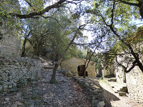
- Follow Comps 4.2 km Grospierres 3.5 km Descend via a very stony path that passes by the Notre Dame des Songes chapel. Legend has it that this chapel was built in the 14th century following a vow made by the wife of a crusader in difficulty in the Holy Land. At the next crossroads, turn right. The path goes around the ruined village of Chastelas to the Font Vive junction.
- Follow Résurgence 0.4 km Go up a few metres then turn right onto a path that goes down to the spring (swimming is not allowed here). Go back up the same path to return to the Font Vive junction. Follow Comps 3.3 km Grospierres 2.6 km Descend along a path to the Chastelas junction.
- Follow Grospierres 2.4 km Leave the GR4. Descend along a path marked in white and yellow and join a tarmac road. Turn right and follow this road for a few metres, then at the end of the tarmac, turn left onto a dirt track. After 200 m, leave the road and follow a path on the right. At the next junction, turn left onto a path that runs alongside a fence. Go through a gate and follow the ridge. Descend towards the village, crossing a campsite.
- When you reach the L'Eglise and Grospierres Chef-lieu junctions, follow the Info Rando signs for 0.3 km. Return to your starting point.
- Departure : Hiking information board - next to the multi-purpose hall
- Arrival : Hiking information board - next to the multi-purpose hall
- Towns crossed : GROSPIERRES
Forecast
Altimetric profile
Information desks

Office de Tourisme Gorges de l'Ardèche - Ruoms
9 rue Alphonse Daudet, 07120 Ruoms

Office de Tourisme Gorges de l'Ardèche - Vallon-Pont-d'Arc
16 rue des Abeilles, 07150 Vallon Pont d’Arc
Access and parking
From Vallon Pont d'Arc, head towards Ruoms then turn onto the D111 towards Alès. Go through the village of Grospierres Gare. 500 metres after the roundabout, head towards Grospierres village. Park in the salle polyvalente car park.
Parking :
Parking garage multifunctional hall
Report a problem or an error
If you have found an error on this page or if you have noticed any problems during your hike, please report them to us here: